
Introduction
The 2023 Passport Program will take you on adventures across the Delaware State Parks, where you can explore amazing scenic locations, jump into diverse programming opportunities, and discover all the ways we interpret the important resources harbored in the parks! Participants can accomplish any 25 of the 31 total challenges listed below to complete the program and qualify for a free 2024 annual park pass, as well as other awesome park prizes. Download the checklist from the top of the blue side bar to help you and your family keep track of the ways you have stamped your passport.
All photos and additional required information must be submitted by November 30, 2023. Limited to one annual pass per household. Participant must be in every submitted photo, but family, friends and pets are encouraged to join in on the fun!
Check out the new Total Parks Experience challenges!
These 11 tasks will challenge you and your group to get involved in the diverse opportunities that the parks offer. When submitting make sure to state the relevant challenge, park name, and if applicable, the program name in the notes section of the passport submission form along with a picture of yourself during the program or visit.
1. Go on a guided hike
Go on a guided hike through any of our parks. Find hikes on our programming webpage by searching "Hikes" in the Choose a Category drop down function.
When submitting make sure to state the park name, program and date in the notes section of the passport submission form along with a picture of yourself during the program.
2. Visit a historical museum
Visit a historical museum, interpretive center or tour a historic site. Some historic tours can be found on our programming webpage by searching "History" in the Choose a Category drop down function.
Required picture of yourself must be taken inside the museum, interpretive center, or during a historic tour.*
3. Volunteer at a park
Check out opportunities on our volunteering webpage where the volunteer calendar can point you to a variety of meaningful and enjoyable projects that you, your family and friends can be a part of. Most projects last as little as an hour or two and Family Volunteer Days are great for families with small children who all want to get involved.
When submitting make sure to state the park name, volunteer program and date along with a picture of yourself during the program.
4. Visit a nature center
Visit one of our many Nature Centers in the parks and enjoy information and exhibits about the rich natural resources of the area.
When submitting make sure to state what nature center you visited along with a picture of yourself inside the center during the visit.
5. Attend a park concert or arts program
Look for concerts at different parks on our concerts webpage or attend an arts program by searching the "Art Programs" or "Crafts + DIY" categories on our programming webpage.
When submitting make sure to state the park name, program and date in the notes section of the passport submission form along with a picture of yourself during the program.
6. Attend a lantern tour or evening program
Find these programs by searching the "Evening Programs" or "Star-Gazing" categories on our programming webpage.
When submitting make sure to state the park name, program and date in the notes section of the passport submission form along with a picture of yourself during the program.
7. Go rock climbing at Alapocas Run State Park
Turn the adventure up a notch and go rock climbing at Alapocas Run State Park. Find available programs listed on our rock climbing page.
When submitting make sure to state the program and date in the notes section of the passport submission form along with a picture of yourself during the program.
8. Attend a program on the water
Attend a program on the water. These programs can be found all across the state and include kayaking, canoeing, or a ferry ride out to Fort Delaware. Find these programs by searching for the "Kayaking + Canoeing" category on our programming webpage or by visiting our canoe, kayak and paddle webpage.
When submitting make sure to state the park name, program and date in the notes section of the passport submission form along with a picture of yourself during the program.
9. Join a fishing program
Go Fish! Join a fishing program at one of our parks. These programs can be found by searching the "Fishing" category on our programming webpage or by checking out our fishing webpage.
When submitting make sure to state the park name, program and date in the notes section of the passport submission form along with a picture of yourself during the program.
10. Participate in a special seasonal activity
Attend a park-run special seasonal event or activity such as hayrides and holiday programs. Some of these programs can be found by searching for the "Special Events + Festivals" category on our programming webpage. Hayride programs can be found on our hayrides webpage.
When submitting make sure to state the park name, program and date in the notes section of the passport submission form along with a picture of yourself during the program.
11. Visit a Delaware state-dedicated Nature Preserve
Check out one of the many important nature preserves found around our state. Some are more easily accessible than others, and they have specific rules to follow when visiting, so take a look at this blog post that will help guide you to one of your region's protected areas: Nature Preserves to Hike in Delaware | destateparks.blog
Discover incredible landscapes and significant sites listed below!
These 20 tasks will challenge you to visit specific park locations across the state and take a picture of yourself or your group at the designated landmarks.
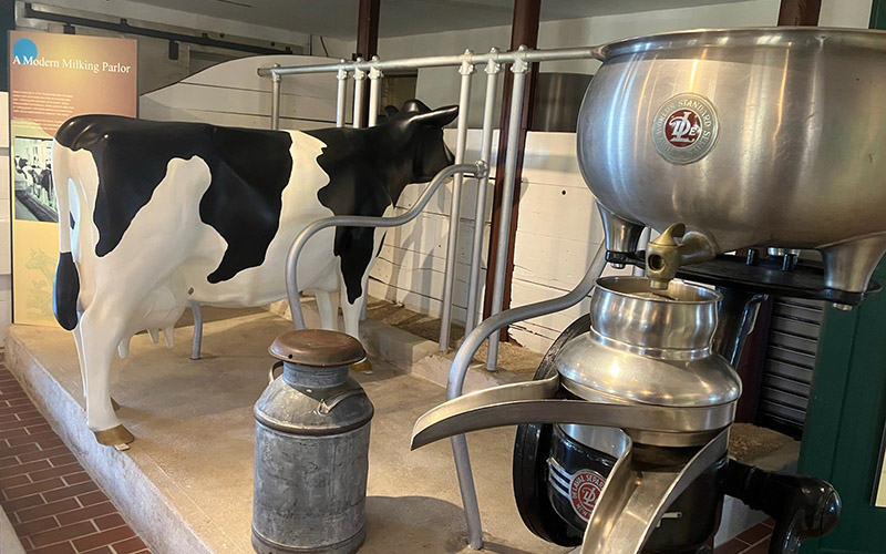
Alapocas Run State Park
Standing in the current Blue Ball Barn, it can be difficult to imagine an agricultural landscape filled with cows. The cow in our exhibit is a reminder of the dairying history of our site and county. Dairy cows along with other farm animals were raised here initially for the Nemours Estate and later by tenant farmers. We invite you to explore the history of our landscape thorough the Milking Parlor exhibits.
Park address: 1914 W. Park Drive, Wilmington, DE 19803
Passport photo: Cow in Milking Parlor
Trail/directions: Located on the first floor of the Blue Ball Barn
GPS coordinates: 39.776674239490646, -75.54543533711612
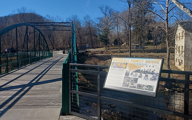
Auburn Valley State Park
Auburn Valley State Park has a rich industrial history and a legacy of revitalization. This wayside highlights the preservation of the bridge, and the family it’s named for.
Park address: Mason Dixon Trail, 664, 698 Benge Rd, Hockessin, DE 19707
Passport photo: Marshall Family Bridge wayside
Trail/directions: Located in an alcove on the Red Clay Creek Bridge, a short walk from the parking lot
GPS coordinates: 39.80709335934576, -75.67940230408969
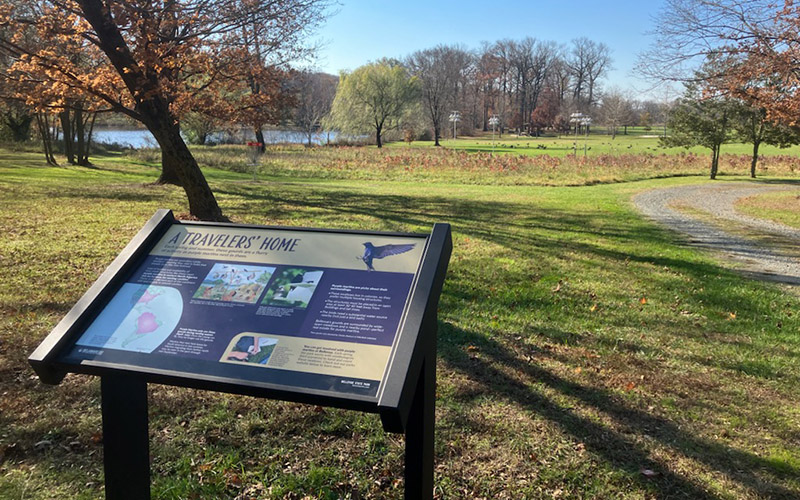
Bellevue State Park
Walking through the disc golf course you’ll find yourself in prime purple martin nesting habitat. Discover how humans play a part in this bird’s migration journey and see their unique birdhouses near this wayside.
Park address: Bellevue State Park - Main Parking Lot, Wilmington, DE 19809
Passport photo: A Travelers’ Home wayside
Trail/directions: From the parking lot, head east along the Oval Track. The wayside will be a short distance from the Purple Martin houses
GPS coordinates: 39.77879, -75.49857
Brandywine Creek State Park
The Rocky Run bridge can be reached via the Thompson’s Bridge parking lot. You will enter on the Brandywine Trail and follow it approximately 1/3 of a mile to the bridge. The original Rocky Run bridge was part of the first roadway in this area, that bridge was destroyed by flooding and replaced with the bridge you see today in 2015. Enjoy beautiful views and the tranquil sound of the creek.
Park address: 4001 Thompson Bridge Road, Wilmington, DE 19807
Passport photo: Rocky Run Bridge
Trail/directions: Park at the Thompson Bridge road parking lot and hike approximately 0.3 miles on a flat trail to the bridge.
GPS coordinates: 39.81197216145809, -75.56628896411439

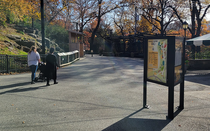
Brandywine Zoo
Start your Brandywine Zoo adventure by taking a look at this map which reveals the exhibits you’ll come across on your visit.
Park address: 200 N Park Dr, Wilmington, DE 19802
Passport photo: Welcome kiosk map
Trail/directions: The kiosk greets you immediately upon passing the Zoo’s ticket windows
GPS coordinates: 39.7560, -75.5497
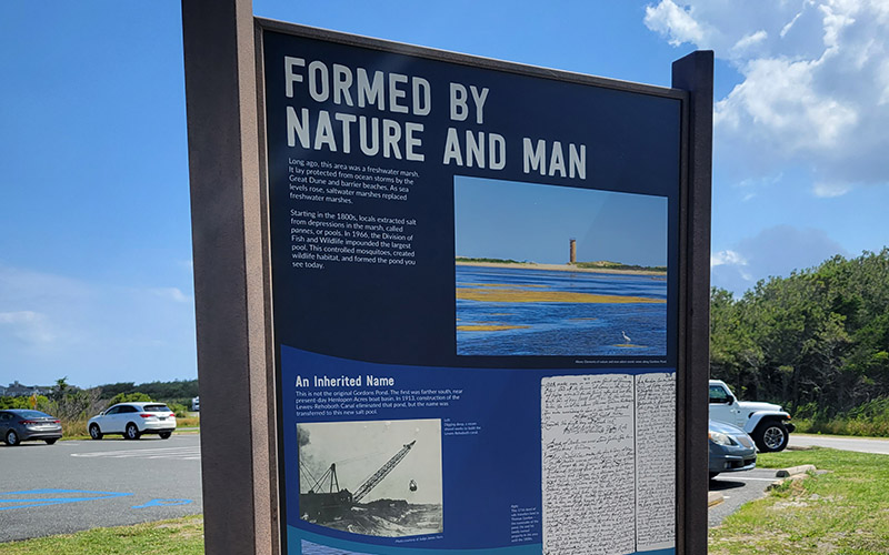
Cape Henlopen State Park, Gordon’s Pond Area
Find out how this land has changed through time and how it’s managed today to benefit people as well as wildlife.
Park address: 61 Ocean Dr, Rehoboth Beach, DE 19971
Passport photo: Formed by Nature and Man kiosk interpretive panel
Trail/directions: The kiosk is located next to Gordons Pond Pavilion, at the Gordons Pond State Park Area
GPS coordinates: 38.74219347934667, -75.08170747380147
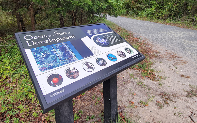
Delaware Seashore State Park, Fresh Pond Area
This maritime forest is a refuge from surrounding development. Discover the wildlife that thrives here, thanks to the conservation of park land.
Park address: Hickman Rd, Ocean View, DE 19970
Passport photo: Oasis in a Sea of Development wayside
Trail/directions: From the parking lot, walk the short distance to the intersection of the Prickly Pear Trail and Fred Hudson Road Trail.
GPS coordinates: 38.56346081133544, -75.07230768083588
Fenwick Island State Park
Before this area became a park, the forces of nature constantly changed the narrow strip of barrier dunes between the Atlantic Ocean and Little Assawoman Bay. This area remained largely undisturbed as the towns of Bethany Beach and Fenwick Island grew around it. With an unobstructed view, this is one of the best places in Delaware to watch sunsets and sea birds dipping and diving into the Bay.
Park address: 36859 Coastal Highway, Fenwick Island, DE 19944
Passport photo: Assawoman Recreation Area on the bayside of Coastal Highway
Trail/directions: No Trail
GPS coordinates: 38.497572, -75.05608
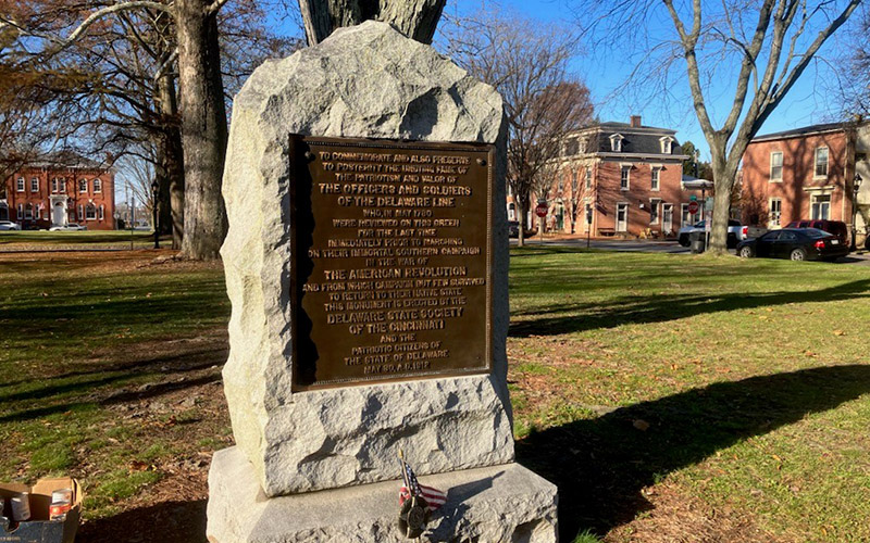
First State Heritage Park
Dedicated in 1912 to the soldiers of the Delaware Line - the Delaware State's contribution to the Continental Army in the Revolutionary War - this monument stands as a clear reminder of the Dover Green's historical significance. Although The Green's appearance has changed over time from unadorned colonial market square to a tranquil park-like setting in line with Victorian sensibilities, it has always been a place where history happened. Standing on this storied half-acre, you walk in the footsteps of Revolutionaries fighting for independence, delegates who gathered to ratify a national constitution, abolitionists who battled to end the scourge of chattel slavery, suffragists who crusaded for women's rights, and activists who struggled and continue to advocate for the powerful ideal of a more perfect Union.
Park address: The Green, Dover, DE 19901
Passport photo: Delaware Line Monument
Trail/directions: In front of 25 The Green, Dover DE 19901
GPS coordinates: 39.156373, -75.523155
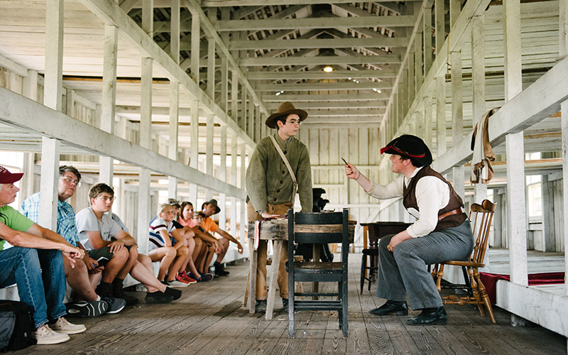
Fort Delaware State Park
The best way to experience Fort Delaware is to talk to the people that inhabit it! Make sure you ask each of our costumed interpreters about life on Pea Patch Island and snap a photo with them in the background.
Park address: 45 Clinton St, Delaware City, DE 19706
Passport photo: Take a photo with one of Fort Delaware's costumed historical interpreters either with you/your group or in the background of your adventure at the Fort.
Trail/directions: No Trail
GPS coordinates: 39.589340223024664, -75.56723996646433
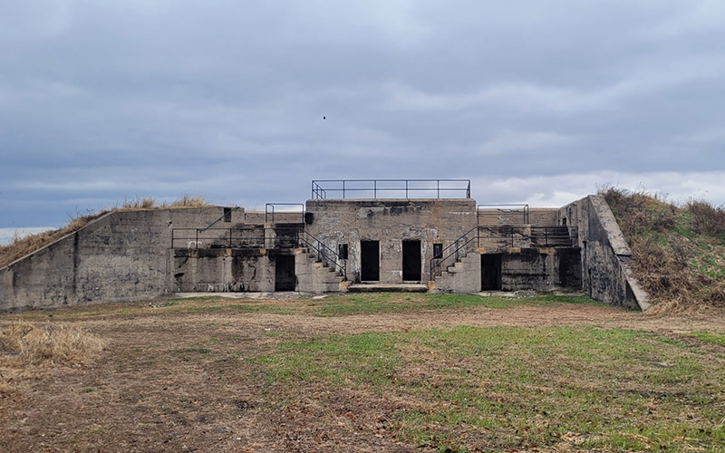
Fort DuPont State Park
Completed in 1904, Battery Elder consisted of two 15-pounder rapid-fire guns. It was meant to protect the minefield in the river at relatively close range against potential attackers in the Delaware River. The rooms at the bottom of the stairs were for storage of the projectiles, and the smaller rooms under the stairs were for the implements necessary for the loading process. This battery was active until 1943.
Park address: Fort DuPont State Park, Wilmington Ave, Delaware City, DE 19706
Passport photo: Battery Elder
Trail/directions: Park at the parking lot at the point (the end of the road on Wilmington Avenue/Old Battery Lane) and take the path closest to the river. This path will take you to the back side of Battery Elder.
GPS coordinates: 39.571214, -75.578738
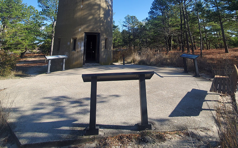
Fort Miles Historical Area
This tower is one of many that were built to keep a vigilant eye over our coast. See the tower’s rooftop views from these ground-level waysides.
Park address: Tower 7: The Observatory, Lewes, DE 19958
Passport photo: Tower 7 rooftop views waysides
Trail/directions: The three waysides sit at the base of Tower 7. A parking lot is directly adjacent to the tower.
GPS coordinates: 38.776348118077095, -75.0927754532669
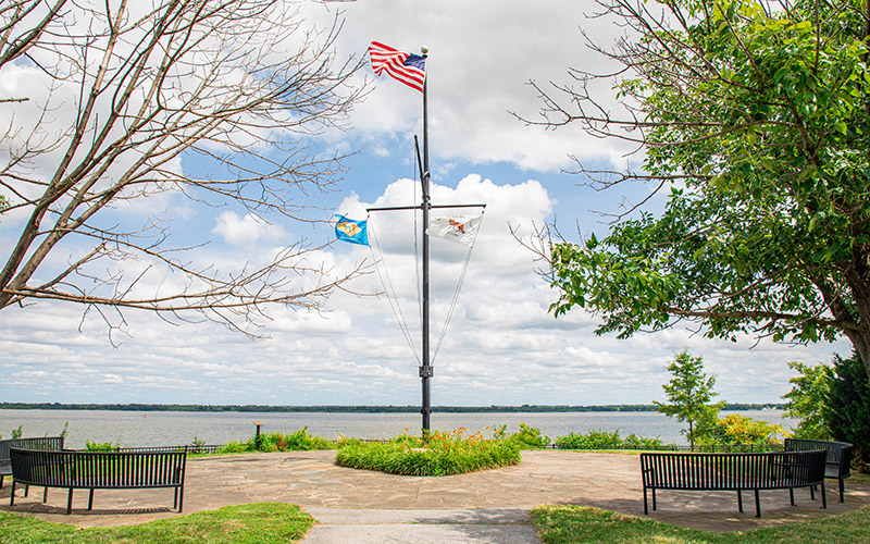
Fox Point State Park
Fox Point was not actually named after the animal—if was named after S. Marston Fox, who spent the last 25 years of his life working to protect the land that the park sits on today. Featuring a playground, picnic pavilions, and a trail along the river, it is a great gathering space for families and groups. Fox Point State Park offers excellent views of the Philadelphia skyline, the Delaware River, and local water traffic.
Park address: Lighthouse Rd, Wilmington, DE 19809
Passport photo: Flag Pole
Trail/directions: Riverview Trail
GPS coordinates: 39.758701, -75.487717
Holts Landing State Park
As you walk down the boardwalk on the Seahawk Trail towards the woods, on either side you find yourself surrounded by incredible plants that make up a key component of this marshy ecosystem- grass! However, this is not any ordinary grass. Rather, you can spot multiple types of marsh grasses sprouting up from the mud and pools of salty water. These grasses include the wispy, green saltmeadow hay, and the tall, smooth cordgrass. All these grasses form an essential aspect of this bountiful marshland.
Park address: 27046 Holts Landing Rd, Dagsboro DE 19939
Passport photo: Marsh Grasses
Trail/directions: Seahawk Trail, by the seated viewing area at the edge of the woods past the Marsh Boardwalk
GPS coordinates: 38.59078587791364, -75.13140423652388
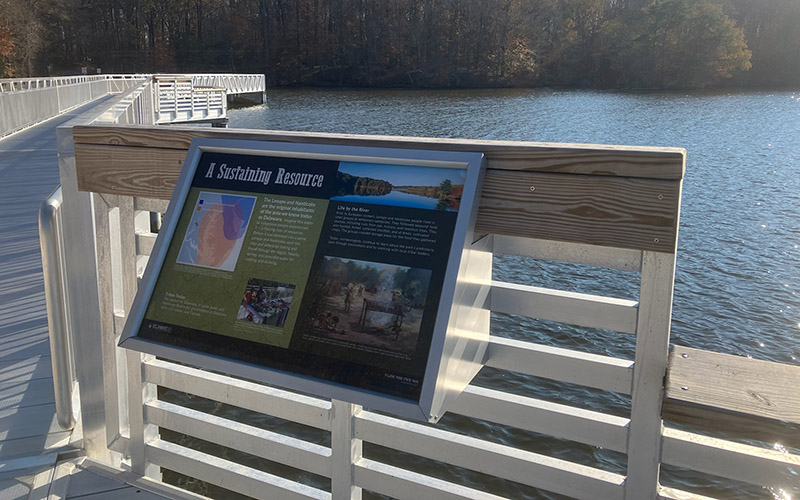
Killens Pond State Park
Killens Pond was once a flowing river of resources for the Indigenous inhabitants of the area. Learn how the Lenape and Nanticoke used these waters and about their presence in Delaware today.
Park address: Killens Pond State Park Nature Center, Felton, DE 19943
Passport photo: A Sustaining Resource wayside
Trail/directions: Head southeast along the Pondside Nature Trail from the nature center. The wayside is the second of three located along the pedestrian walkway portion of the trail
GPS coordinates: 38.9820247, -75.5301543
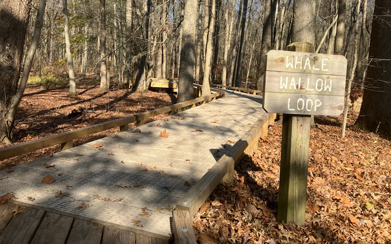
Lums Pond State Park
This year’s passport location is the renovated Whale Wallow Loop trail. A .1 mile loop boardwalk and stone trail located behind the nature center in the Lums Pond Nature Preserve. This trail takes you through the forest and includes an overlook of a Delmarva Bay. Delmarva bays are special types of wetlands that are seasonally flooded and provide habitat for a variety of amphibians, insects and birds.
Park address: 1068 Howell School Rd, Area 5 parking lot, Bear, DE 19701
Passport photo: Whale Wallow Loop Trail behind the Nature Center
Trail/directions: Whale Wallow Loop
GPS coordinates: 39.563201, -75.729244
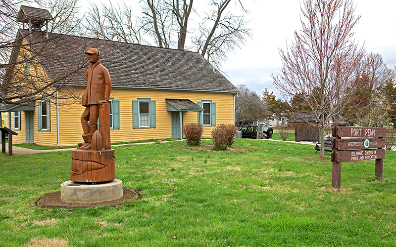
Port Penn Interpretive Center
The Waterman is a chainsaw carving commissioned in 2007 by the Port Penn Area Historical Society, and created by Jacquin Smolens. The statue represents several aspects of the seasonal economy that was so important to Port Penners in the late 19th and early 20 centuries. The waterman is clothed in the traditional rubber boots and raincoat, a sturgeon at the base represents the fishing industry, and a turtle next to the waterman, represents the connection to the surrounding wetlands.
Park address: 5 Port Penn Rd, Middletown, DE 19709
Passport photo: Waterman Statue
Trail/directions: No Trail
GPS coordinates: 39.51741740156213, -75.57942979586511
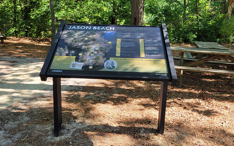
Trap Pond State Park
For generations, this area—known as Jason Beach—was a vibrant gathering place for the local Black community Hear and read about the history of Jason Beach at this wayside.
Park address: Cypress Point Disc Golf Course, Road 450, Laurel, DE 19956
Passport photo: Jason Beach wayside
Trail/directions: Head west from the Cypress Point parking lot, towards the pavilions. You’ll pass a couple other waysides before reaching the large Jason Beach wayside, across from the first pavilion
GPS coordinates: 38.52509397697967, -75.47269618309898
White Clay Creek State Park
This "Nine-Foot Road" was built in 1928—part of a short-lived campaign to build low-cost roads. It is designed to be only half paved. The original concrete lane is nine feet wide while the other lane is intentionally left as dirt. One of only a few in New Castle County, the primary purpose of this road was to give isolated farmers a way to transport their goods to market. This road connects you to our newest trail in the park, the accessible Tri-Valley trail.
Park address: 70 Nine Foot Road Parking Lot, Newark, DE 19711
Passport photo: The hiking trail section of the Nine Foot Road
Trail/directions: This spot is part of the Tri-Valley Trail
GPS coordinates: 39.725142, -75.742994
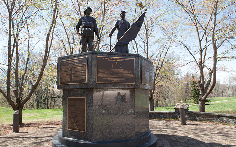
Wilmington State Parks
Prejudices and bigotry plagued black soldiers each and every day, but these men looked beyond their flawed nation and recognized the potential their home had and the importance of fighting for freedom. This memorial is dedicated to African American soldiers who received the Medal of Honor award. The award was created during the Civil War and is presented by the United States government to a member of its armed forces who have distinguished themselves at the risk of their own life above and beyond the call of duty in action against an enemy of the United States.
Park address: Corner of Baynard Blvd and 18th Street., Wilmington DE 19806
Passport photo: African American Medal of Honor Memorial
Trail/directions: Sidewalk at the corner of Baynard Blvd and 18th Street
GPS coordinates: 39.75497315676701, -75.5467385590376